


How to Get to Mount Rinjani: A Simple Travel Guide
Getting to Mount Rinjani is easy. You just need to follow a few simple steps. First, you must travel to Lombok Island. Once you arrive in Lombok, you can choose the best transport to the mountain.
Step 1: How to Get to Lombok Island from Bali
You can travel from Bali to Lombok in three easy ways:
- Take a Flight: Fly from Ngurah Rai Airport in Bali to Lombok International Airport. Daily flights are always available. From the Lombok airport, you can hire a car to the trekking villages.
- Take a Slow Ferry: This ferry runs every two hours from Padang Bai (Bali) to Lembar Harbor (Lombok). The sea trip takes about 4 to 6 hours. From Lembar Harbor, you can take a car to the mountain. We highly recommend booking your ride in advance to avoid unofficial ticket sellers at the harbor.
- Take a Fast Boat: Fast boats run daily from Padang Bai to Bangsal Harbor or Senggigi. They usually leave twice a day, in the morning and afternoon. Booking your ticket early is the safest option.
Step 2: Choose Your Mount Rinjani Trekking Route
There are three main entrance gates to climb Mount Rinjani. The most popular starting points are:
- Senaru Village
- Sembalun Village
- Torean Village
Senaru Trekking Route: The Shaded Jungle Trail
Senaru route is the oldest and most famous path on Mount Rinjani. It sits on the northern side of the mountain. This trail takes you straight up to the beautiful Senaru Crater Rim (2,641 meters).
This trail is very different from the other routes. Instead of walking under the hot sun, you will hike through a dense tropical rainforest. The thick trees give you excellent shade from the heat. However, the path can be very humid. You must also watch your step, as there are many large and slippery tree roots along the way.

Senaru Route: Overview & Technical Details
- Starting Point: Senaru Village in North Lombok. It sits at around 601 meters above sea level.
- Main Destination: Senaru Crater Rim (Pelawangan Senaru). It sits at 2,641 meters above sea level.
- Distance: The trail is about 9.5 kilometers long from the gate to the rim.
- Time Needed: It takes 6 to 8 hours of continuous uphill walking to reach the campsite.
- Difficulty Level: Moderate. The trail goes straight up, so it is tiring for your muscles. However, it is safer than the Torean path and less dusty than the Sembalun path.
What Will You See Along the Way?
- The Tropical Rainforest: You will walk under giant mahogany trees and see wild orchids. The thick trees protect you from the hot sun for the first 5 hours.
- Wild Animals: The jungle is full of birds. You will also see playful groups of black lutung monkeys (ebony leaf monkeys) swinging in the trees.
- The Ultimate Crater View: When you reach the top, you get the best view of Mount Rinjani. You can see the blue Segara Anak Crater Lake and the active Barujari volcano. On a clear day, you can even see Mount Agung all the way in Bali!
Recommend trip for you:
- 2D1N Crater Rim Senaru
- 3D2N Crater plus Lake Segara Anak
- 3D2N Complete Rinjani Destination ( Crater Rim Senaru, Lake Segara Anak, Crater Rim Sembalun and Summit Rinjani )
- 4D3N Rinjani Trekking – Complete Rinjani Destination for family with kids.
2. Sembalun Trekking Route:
The Grand Savanna PathThe Sembalun route is the most popular and famous trail on Mount Rinjani. It sits on the eastern side of the mountain. This path is the official and most direct highway to reach the actual summit (3,726 meters).
This path is very different from the green rainforests of Senaru. Sembalun is famous for its huge, rolling savanna hills. The grass looks beautifully gold and green. You will enjoy amazing panoramic views all day long. However, there are very few trees, so you will walk under the intense, hot sun.

Sembalun Route: Overview & Technical Details
- Starting Point: Sembalun Village in East Lombok. It starts high up at 1,156 meters above sea level.
- Main Destination: Sembalun Crater Rim (Pelawangan Sembalun) at 2,639 meters, leading to the Summit at 3,726 meters.
- Distance: The trail is about 10 kilometers long to reach the crater rim camp.
- Time Needed: It takes 7 to 8 hours to reach the rim, and another 3 to 4 hours to climb to the summit the next morning.
- Difficulty Level: Hard. The walk through the savanna is flat at first, but the final climb to the crater rim is very steep. The trail is also very dusty.
What Will You See Along the Way?
- The Seven Hills (Bukit Penyesalan): This is a famous series of steep hills before the crater rim. The climb is tough, but the view of the valley below is incredible.
- Edelweiss Flowers: As you get closer to the top, you will see beautiful wild Edelweiss flowers growing along the volcanic soil.
- The Majestic Sunrise: Climbing from the Sembalun rim to the summit at 2:00 AM rewards you with a breathtaking sunrise over the clouds. You can see the shadow of Rinjani cast across the ocean.
We recommend these trips for you:
- 2 days Summit Rinjani. Start from Sembalun and finish at Sembalun
- 2 days Crater Rim Sembalun
- 3 days Summit Rinjani. You will see all parts of Mount Rinjani. Start from Sembalun and finish at Senaru village.
- 4D3N Explore Rinjani. Start Sembalun and finish in Senaru Village.
3. Torean Trekking Route: Lombok’s Jurassic Park
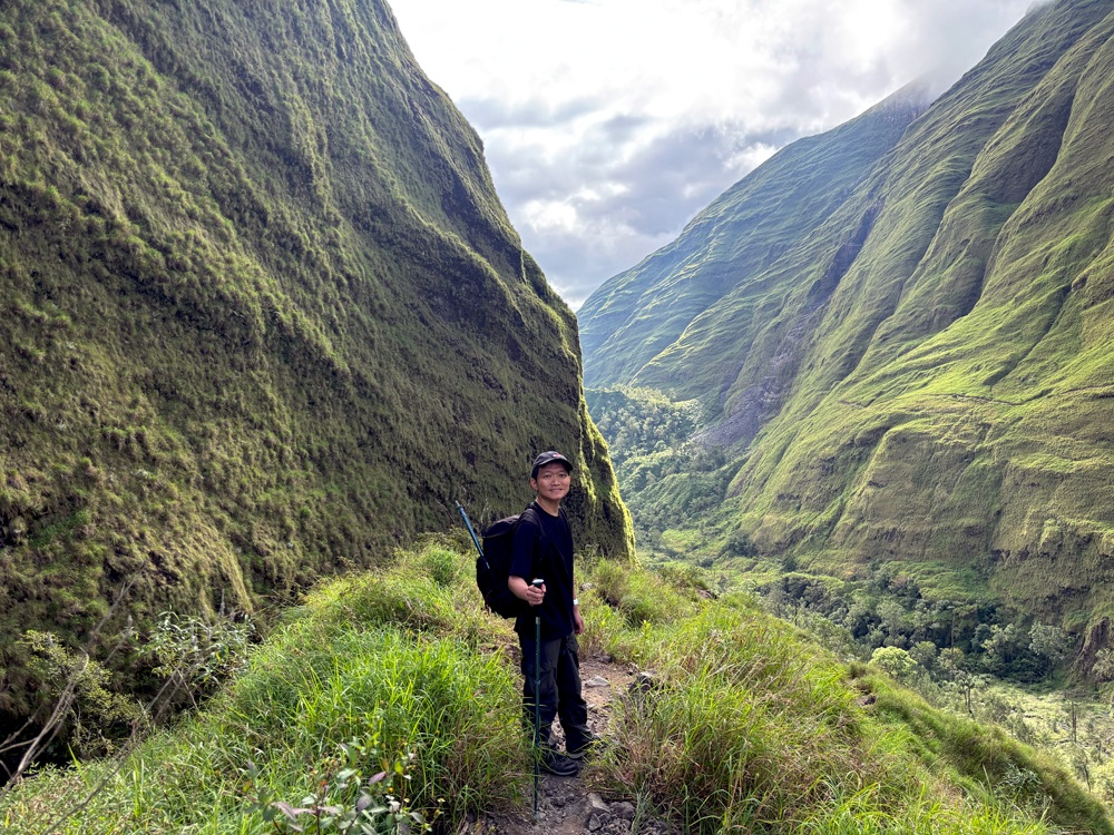
The Torean route is the most spectacular and dramatic trail on Mount Rinjani. It officially opened as an authorized trekking path in 2020. Instead of open grass hills, this trail moves straight through a giant, deep volcanic valley.
Many hikers nickname it the “Jurassic Park” route. This is because it features towering green canyon walls, emerald rivers, and prehistoric moss-covered rocks.
While it is exceptionally beautiful, the trail is highly technical. It has narrow ridges and steep drop-offs, so you must always focus on safety.
Torean Route: Overview & Technical Details
- Starting Point: Torean Village in North Lombok (~585 meters above sea level).
- Main Destination: Segara Anak Crater Lake (~2,008 meters above sea level).Distance: The trail spans about 11.5 kilometers from the gate to the lake.
- Time Needed: It takes a long 8 to 10 hours of walking through the canyon beds.
- Difficulty Level: Challenging. The path is physically demanding and technically tricky. It is best for hikers who are not afraid of heights.
What Will You See Along the Way?
- Penimbungan Waterfall: This is a massive, towering waterfall crashing down into the canyon. You can view its raw power from a spectacular cliffside viewpoint.
- The Jurassic Canyon Walls: You will walk between giant green mountain walls that look like a scene from a prehistoric movie.
- Natural Hot Springs: Before reaching the lake, you will pass natural sulfur hot springs. Hikers love to rest their sore muscles in the warm, healing waters.
Recommend trip for you?
- 3D2N Sembalun Torean. The trekking start from Sembalun end finish in Torean
- 4D3N Sembalun Torean. The trekking suites for family and photographer to capture the moment with slow step.
Summary: Which Rinjani Route is Best for You?
- Choose Senaru if you want lots of shade, beautiful monkeys, and an easier, safer trail to a great viewpoint.
- Choose Sembalun if you want to reach the actual summit and love wide, golden savanna views.
- Choose Torean if you want an adventurous, movie-like trek through deep canyons and waterfalls.
Mount Rinjani Trekking FAQs
Do you need a guide to climb Mount Rinjani?
Yes, you must hire a registered guide and local porters to climb Mount Rinjani. The national park does not allow tourists to hike alone for safety reasons. The guides know the trails well and keep you safe.
How much does it cost to hike Mount Rinjani?
The cost usually ranges from $150 to $350 (approx. IDR 2,300,000 to IDR 5,500,000) per person. This price depends on your package (sharing or private). It generally includes national park tickets, a guide, porters, tents, and meals.
How hard is the climb to the summit?
The climb to the summit is very hard and challenging. You start walking at 2:00 AM on loose volcanic ash and sand. For every two steps forward, you often slide one step back. You need good stamina and strong mental focus.
What is the best month to climb Mount Rinjani?
The best time to climb is during the dry season, from April to October. The trails are dry, safe, and open to the public. The national park closes completely from January to March every year due to heavy rainy season storms.
Where do you sleep during the trek?
You will sleep in camping tents on the mountain. Your local porters will hike ahead of you to set up the tents at the crater rim or the lake. They will also provide sleeping mats, sleeping bags, and pillows.
What happens to the trash on Mount Rinjani?
The national park has a “pack-in, pack-out” rule. Your trekking guide and porters are responsible for carrying all plastic and food trash back down the mountain. Hikers are also strongly encouraged to keep the trails clean.
Pingback:Duration Variability Online
Pingback:Drug Response Timing
Pingback:Brand vs Generic Variability Overview